
Page 56 - DGH_Annual_Report
P. 56
56 INDIA'S HYDROCARBON OUTLOOK 2024-2025
• Basin datasets and studies: are also archived whenever the same are
provided by E&P Operators.
As of 31.03.2025, NDR has archived primary
datasets of 6,541 LKM 2D seismic, 554 SKM 3D The basin has 1158 coal-seam gas wells (61
seismic and 2 conventional wells (all exploratory). exploratory).
Multiple flavour of reprocessed seismic datasets
Source: DGH Internal
Basin appraisal and regime-wise active acreage:
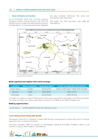
Location Basin area(skm) Appraised (skm) Active acreage [Nos./Area(skm)]
South Rewa 44,667 18,476 (41%) NELP: 1/790 OALP: 1/906 CBM: 7/2,958
Satpura 7,890 2,632 (33%) CBM: 1/1,771
Damodar 4,623 4,623 (100%) CBM: 6/1,453
The basin occupies an area of 57,180 sq km. It has been appraised to the extent of 25,731 sq km (45%).
The active acreage nos. across regime(s) are 16 with area 7,878 sq. km (14% of basin area).
Bidding opportunities:
South Rewa: 2 CBM (SCBM) blocks with 331 sq km area
2.3.10 HIMALAYAN FORELAND BASIN
Himalayan Foreland is a Category III basin with entirely undiscovered in-place, that calls for intense
exploration for a potential discovery.
The basin overlaps with the state(s) of Chandigarh, Haryana, Himachal Pradesh, Jammu and
Kashmir, Punjab, Uttar Pradesh, Uttarakhand.