
Page 51 - DGH_Annual_Report
P. 51
India's Sedimentary Basins: Subsurface Insights 51
Basin appraisal and regime-wise active acreage:
Location Basin area(skm) Appraised (skm) Active acreage [Nos./Area(skm)]
Onland 202,888 71,011 (35%) NELP: 3/9,155 OALP: 5/13,260 DSF: 1/1,472
The basin occupies an area of 202,888 sq km. It has been appraised to the extent of 71,011 sq km
(35%). The active acreage nos. across regime(s) are 9 with area 23,886 sq. km (12% of basin area).
Bidding opportunities:
Onland: 1 OALP (Round X) block with 4,275 sq km area
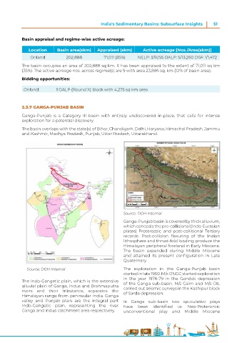
2.3.7 GANGA-PUNJAB BASIN
Ganga-Punjab is a Category III basin with entirely undiscovered in-place, that calls for intense
exploration for a potential discovery.
The basin overlaps with the state(s) of Bihar, Chandigarh, Delhi, Haryana, Himachal Pradesh, Jammu
and Kashmir, Madhya Pradesh, Punjab, Uttar Pradesh, Uttarakhand.
Source: DGH Internal
Ganga-Punjab basin is covered by thick alluvium,
which conceals the pre-collisional (Indo-Eurasian
plates) Proterozoic and post-collisional Tertiary
records. Post-collision flexuring of the Indian
lithosphere and thrust-fold loading produce the
Himalayan peripheral foreland in Early Miocene.
The basin expanded during Middle Miocene
and attained its present configuration in Late
Quaternary.
Source: DGH Internal The exploration in the Ganga-Punjab basin
started in late 1950. M/s ONGC started exploration
in the year 1978-79 in the Gandak depression
The Indo-Gangetic plain, which is the extensive of the Ganga sub-basin. M/s Cairn and M/s OIL
alluvial plain of Ganga, Indus and Brahmaputra carried out seismic surveys in the Kashipur block
rivers and their tributaries, separates the of Sarda depression.
Himalayan range from peninsular India. Ganga
valley and Punjab plain are the integral part In Ganga sub-basin two speculative plays
Indo-Gangetic plain, representing the river have been identified i.e. Neo-Proterozoic
Ganga and Indus catchment area respectively. unconventional play and Middle Miocene