
Page 46 - DGH_Annual_Report
P. 46
46 INDIA'S HYDROCARBON OUTLOOK 2024-2025
Basin appraisal and regime-wise active acreage:
Location Basin area(skm) Appraised(skm) Active acreage [Nos./Area(skm)]
Shallow water 90,380 90,380 (100%) OALP: 2/10,237
Deepwater
Shallow water 489,620 489,620 (100%) OALP: 1/1,113
The basin occupies an area of 580,000 sq km. It has been appraised to the extent of 580,000 sq km
(100%). The active acreage nos. across regime(s) are 3 with area 11,350 sq. km (2% of basin area)
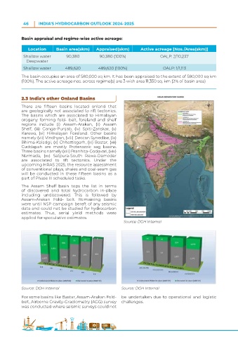
2.3 India's other Onland Basins
There are fifteen basins located onland that
are geologically not associated to rift tectonics.
The basins which are associated to Himalayan
orogeny forming fold- belt, foreland and shelf
regions include (i) Assam-Arakan, (ii) Assam
Shelf, (iii) Ganga-Punjab, (iv) Spiti-Zanskar, (v)
Karewa, (vi) Himalayan Foreland. Other basins
namely (vii) Vindhyan, (viii) Deccan Syneclise, (ix)
Bhima-Kaladgi, (x) Chhattisgarh, (xi) Bastar, (xii)
Cuddapah are mostly Proterozoic sag basins.
Three basins namely (xiii) Pranhita-Godavari, (xiv)
Narmada, (xv) Satpura-South Rewa-Damodar
are associated to rift tectonics. Under the
upcoming HRAS 2025, the resource assessment
of conventional plays, shales and coal-seam gas
will be conducted in these fifteen basins as a
part of Phase III scheduled tasks.
The Assam Shelf basin tops the list in terms
of discovered and total hydrocarbon in-place
including undiscovered. This is followed by
Assam-Arakan Fold- belt. Remaining basins
were until NSP campaign bereft of any seismic
data and could not be studied for hydrocarbon
estimates. Thus, aerial yield methods were
applied for speculative estimates.
Source: DGH Internal
Source: DGH Internal Source: DGH Internal
For some basins like Bastar, Assam-Arakan Fold- be undertaken due to operational and logistic
belt, Airborne Gravity-Gradiometry (AGG) survey challenges.
was conducted where seismic surveys could not